
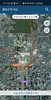
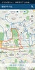
Navigate South Korea's administrative districts effortlessly with the 행정구역 지도 app. This application allows users to view both standard and satellite maps, easily identify regions right down to the town and district level, and effortlessly search for specific localities. Tap on a region name to access detailed information from Wikimedia. Essential location permissions are required to enhance usability. The intuitive interface and rich mapping features make it an invaluable tool for geographical exploration within South Korea.
The app provides a user-friendly experience, enabling smooth navigation and proper identification of any local area. It’s particularly useful for educational purposes, or for those planning to travel or relocate within the country. Features such as detailed map overlays and precise regional data expand beyond simple navigation, facilitating a deep dive into the local geography.
By using 행정구역 지도, individuals can confidently explore South Korea's vast landscape and administrative divisions. The app ensures that users have all the necessary tools at their fingertips to interact effectively with the map, promoting a better understanding of the country’s administrative layout without overwhelming them with unnecessary complexity.
Requirements (Latest version)
- Android 5.0 or higher required
Comments
There are no opinions about 행정구역 지도 yet. Be the first! Comment